



The ‘freak storm’ that wreaked havoc on Penang
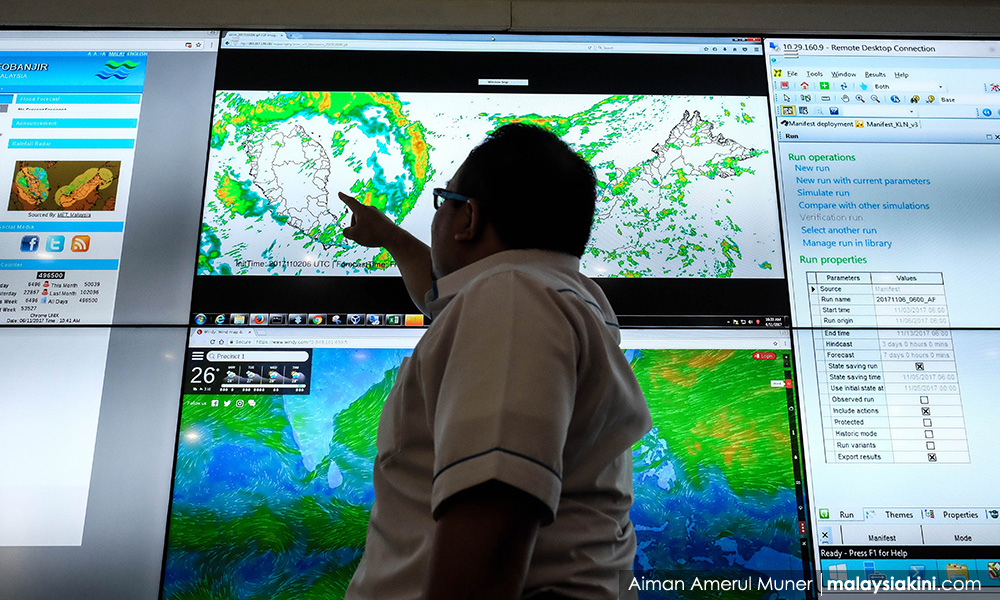
KINIGUIDE | From the late night of Nov 4 into the wee hours of Nov 5, the northwestern region of Peninsular Malaysia, including Penang and Kedah, was lashed by strong winds and unrelenting rain.
At around the same time, Typhoon Damrey slammed into Vietnam, killing at least 61 people.
Penang experienced its heaviest rainfall in recorded history, 315mm in a single day, according to the Penang Water Supply Corporation.
Devastating floods in Penang and parts of Kedah followed.
Malaysiakini puts this unusual weather event into context for this edition of KiniGuide.
Was the violent weather because of Typhoon Damrey?
No. Typhoon Damrey did not hit Penang. Damrey was a full-fledged typhoon. What hit the northwestern peninsula was a “tropical disturbance” referred to as “Invest 95W”.
What's the difference between a tropical disturbance and a typhoon?
A tropical disturbance is the very beginning of a possible typhoon. A tropical disturbance can progress into a tropical depression, then a tropical storm and finally - for this region - a typhoon.
The final stage is referred to as a hurricane in the North Atlantic Ocean and Northeast Pacific or a cyclone in the South Pacific and the Indian Ocean.
A tropical disturbance is an area of low pressure that brings with it clouds and rain. The US National Oceanic and Atmospheric Administration (NOAA) defines it as a discrete tropical weather system with an organised convection that is 200 to 600 kilometres in diameter.
According to the NOAA, if it gathers strength to a sustained wind speed of 20 to 33 knots (37 to 61km/h), it will be upgraded to a tropical depression and if it attains a sustained wind speed of 34 to 63 knots (63 to 117km/h) it is again upgraded to a tropical storm.
Sustained wind of 64 (118km/h) knots and above means, it has developed into a typhoon.
So how did the tropical disturbance over Penang develop?
At the end of October, meteorology enthusiasts have been observing two tropical disturbances that had developed - one over the Spratly Islands, west of the Philippines, referred to as “Invest 95W”, another called "Invest 96W" in the east of the Philippines...
KINIGUIDE | From the late night of Nov 4 into the wee hours of Nov 5, the northwestern region of Peninsular Malaysia, including Penang and Kedah, was lashed by strong winds and unrelenting rain.
At around the same time, Typhoon Damrey slammed into Vietnam, killing at least 61 people.
Penang experienced its heaviest rainfall in recorded history, 315mm in a single day, according to the Penang Water Supply Corporation.
Devastating floods in Penang and parts of Kedah followed.
Malaysiakini puts this unusual weather event into context for this edition of KiniGuide.
Was the violent weather because of Typhoon Damrey?
No. It had nothing to do with Typhoon Damrey. Damrey was a full-fledged typhoon. What hit the northwestern peninsula was a “tropical disturbance” referred to as “Invest 95W”.
What's the difference between a tropical disturbance and a typhoon?
A tropical disturbance is the very beginning of a possible typhoon. A tropical disturbance can progress into a tropical depression, then a tropical storm and finally - for this region - a typhoon.
The final stage is referred to as a hurricane in the North Atlantic Ocean and Northeast Pacific or a cyclone in the South Pacific and the Indian Ocean.
A tropical disturbance is an area of low pressure that brings with it clouds and rain. The US National Oceanic and Atmospheric Administration (NOAA) defines it as a discrete tropical weather system with an organised convection that is 200 to 600 kilometres in diameter.
According to the NOAA, if it gathers strength to a sustained wind speed of 20 to 33 knots (37 to 61km/h), it will be upgraded to a tropical depression and if it attains a sustained wind speed of 34 to 63 knots (63 to 117km/h) it is again upgraded to a tropical storm.
Sustained wind of 64 (118km/h) knots and above means, it has developed into a typhoon.
So how did the tropical disturbance over Penang develop?
At the end of October, meteorology enthusiasts have been observing two tropical disturbances that had developed - one over the Spratly Islands, west of the Philippines, referred to as “Invest 95W”, another called "Invest 96W" in the east of the Philippines.
Even though Invest 95W developed first, as its name suggests, Invest 96W quickly strengthened to become Typhoon Damrey.
Typhoon Damrey made landfall in Vietnam on Nov 4. It dissipated the following day.
Concurrently, Invest 95W crossed into southern Thailand and towards the northwestern Malaysian peninsula.
Still a tropical disturbance at that time, as its path did not provide the right conditions to gather strength, it paled in comparison to Typhoon Damrey, which claimed at least 61 lives.
Nonetheless, Invest 95W still wrecked havoc on Penang and parts of Kedah.
Where is Invest 95W now?
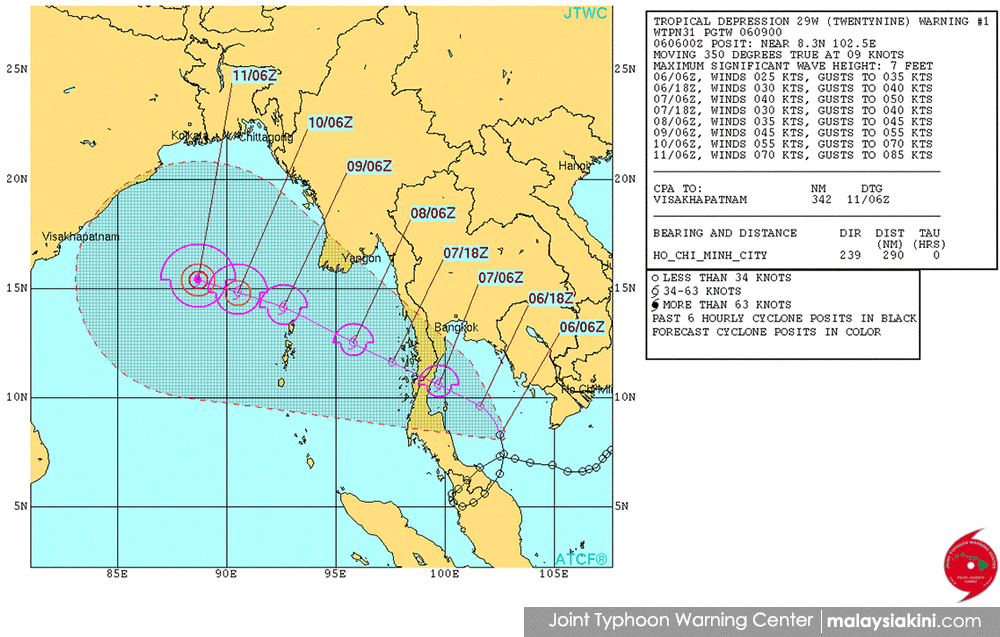
After reaching Penang, it doubled back towards Kelantan and out to the South China Sea before turning northwest towards Thailand.
It did not wreck havoc on Kelantan as tropical disturbances, like typhoons, draw energy from the sea and weaken the longer these spend time over land.
As of today, it has been upgraded to a tropical depression after reaching the sea and assigned the label 29W.
It is expected to bring rough weathers to southern Thailand and Myanmar before heading towards the Bay of Bengal.
What's with the confusing names?
In meteorology, “invest” is an area of disturbed weather that is being monitored by forecast centres. It is short for "investigate".
According to Hurricane Almanac: The Essential Guide to Storms Past, Present, and Future, a disturbed weather being investigated will be given a number, ranging from 90 to 99, followed by an alphabet suffix, depending on the region.
For the Western North Pacific Ocean, which is this region, it is "W". Therefore, the tropical disturbance over Penang was referred to as "Invest 95W".
Once it is upgraded to a tropical depression, it is referred to as only its number and suffix.
The number begins at 01 and increases progressively, like taking a queue number at the hospital, depending on the number of tropical depressions that had occurred in a season.
In the case of Invest 95W, it was renamed "29W" after becoming a tropical depression.
Invest 96W, which began later but became a tropical depression first, was renamed "28W" before finally being renamed "Damrey".
Once a tropical depression is upgraded to a tropical storm or stronger, it will normally be assigned a human name. For certain regions, particular Asia, it can be named after animals in the native language.
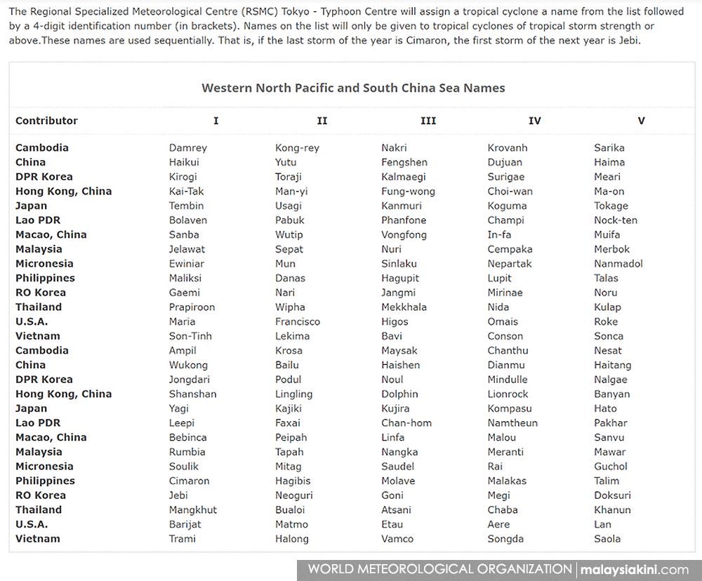
There is a list of pre-determined names for the various regions. For this region, the naming is managed by Regional Specialized Meteorological Centre (RSMC) in Tokyo, with contributions from all countries within it.
For example, with Typhoon Damrey now passed, if 29W develops into a tropical storm or stronger, it will be named "Haikui", which is next on the list.
However, if it only develops into a tropical storm after moving into the Bay of Bengal, it will fall under a different list of names as it is considered to be another region.
This edition of KiniGuide was compiled by NIGEL AW.


Are you sure you want to delete this comment?
This action cannot be undone.