


/file/publisher-c1a3f893382d2b2f8a9aa22a654d9c97/2024/02/596dc9e178f24f43309377814867273d.jpg)

Malacca mega reclamation: EIA doesn't account for 40 floods in 10 years
Mitigation measures for the proposed Malacca land reclamation mega project have not taken into account the 40 recorded floods in areas nearby.
In the Environmental Impact Assessment (EIA) for the Straits of Melaka Waterfront Economic Zone (SM-WEZ) project, the flood impact study only considered overflooding of the seven rivers close to the site.
"Based on the outcomes from the river hydraulics model, the impact of reclamation on river flooding is minimal across all seven rivers under a 100-year average recurrence interval (ARI) with climate change factor (CCF) conditions.
Summary
Despite 40 recorded floods within 5km of the site over the last decade, the project’s EIA only analyses potential overflows from nearby rivers while ignoring local drainage issues and rising rainfall intensity linked to climate change.
The project will cause irreversible loss of mudflats and mangroves, with potential damage to corals.
The site is close to 237 residential areas, commercial areas, institutions and facilities.
Mitigation measures for the proposed Malacca land reclamation mega project have not taken into account the 40 recorded floods in areas nearby.
In the Environmental Impact Assessment (EIA) for the Straits of Melaka Waterfront Economic Zone (SM-WEZ) project, the flood impact study only considered overflooding of the seven rivers close to the site.
"Based on the outcomes from the river hydraulics model, the impact of reclamation on river flooding is minimal across all seven rivers under a 100-year average recurrence interval (ARI) with climate change factor (CCF) conditions.
"For Sungai Lereh, Sungai Melaka, Sungai Sri Melaka, Sungai Umbai, Sungai Punggor, Sungai Duyong, and Sungai Parit Cina, the increase in maximum water levels is insignificant, with differences of less than one centimetre only. No mitigation measures are required.
"However, for Sungai Parit Cina, the proposed reclamation layout does not allow (for an) opening. The proposed mitigation measure is to allow (for) the outlet channel and a reserve width of 84m," the report stated.
Earlier in the report, it identified 40 flood incidents between November 2014 and November 2024 within 5km of the project site.
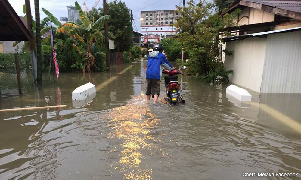
Most of the floods were caused by heavy rain, with some cases being exacerbated by inadequate drainage systems.
In 2023, Kota Laksamana assemblyperson Low Chee Leong told Malaysiakini that reclamation projects have disrupted Malacca's drainage system, resulting in rainwater being diverted instead of being discharged directly into the sea.
The same report cited data from the Malacca weather station, which suggested that climate change has altered the patterns and intensity of rainfall. In 2020, Malacca had six days with rainfall exceeding 50mm, while in 2021, there were 15 such days.
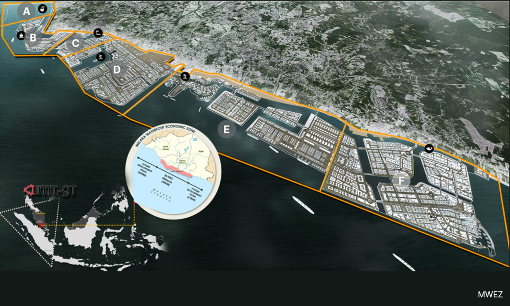
The SM-WEZ aims to reclaim an area of 1,123.41ha, or a bit more than 1,388 football fields, across 16 plots in the development zone along the Strait of Malacca.
The plots comprise seven concession plots and nine potential development areas to be used for commercial and industrial purposes.
The project is part of the state’s overall strategic development plans for the Melaka Waterfront Economic Zone (M-WEZ), which seeks to reclaim 10,117.141ha of land across 33km of the entire Malacca coastline.
Loss of biodiversity
The EIA also noted that the development will permanently destroy mudflats and mangrove trees in surrounding areas, while impacting coral health.
"(The) reclamation project will result in irreversible loss of the mudflat at the (site). The original physical, biological resources and productivity of the reclamation footprint would be lost permanently.
"The loss of mudflats will result in some reduction in the number of resources important to support marine life," it said.
Mudflats provide a habitat and sustenance for several forms of marine life, such as molluscs, crustaceans and worms, while also serving as a breeding ground for certain species of fish.
These mudflats in the proposed reclamation site are where commercially harvested blood cockles are found as well, the report said.
It added that reclamation activities will include 3.19ha of mangrove clearing at Pulau Melaka.
"The original physical, biological resources and productivity of the mangroves at the reclamation footprint at Pulau Melaka would thus be lost and considered as a trade-off.
"However, the magnitude of the impact on the mangroves found outside the reclamation plots is insignificant," it commented.
Mangroves, besides being a form of coastline defence against extreme weather patterns, also act as biodiversity hotspots and carbon sinks.
It further said that existing coral structures could be impacted by sedimentation and turbidity from failed reclamation activities.
"High sedimentation does not necessarily lead to mortality, but it could still have sub-lethal effects," it said, adding that this includes increased susceptibility to disease, bleaching and reduced regeneration from tissue damage.
It warned that such effects could shift dominance of the ecosystem in favour of non-coral species such as sponges and algae.
High sedimentation could also restrict coral recolonisation, it added.
"The loss of the intertidal, mangrove and mudflat as fisheries habitat and nursery grounds at the reclaimed footprint cannot be fully mitigated and is therefore considered a trade-off," it said.
Corals protect the coast by forming a natural barrier against storms, strong waves and floods. They also filter and cleanse water while providing a home for a large variety of marine life.
The report went on to suggest four mitigating measures:
The construction of eco-engineered structures to create and enhance habitats,
Replanting mangroves,
Replanting corals, and
The deployment of artificial reefs.
Other issues
Besides these issues, the proposed site is located close to 237 residential areas, commercial areas, institutions and facilities.
There are 42 residential areas within one to 3km of the site and another 48 between three and 5km away.
The closest residential area to the site is Kampung Hailam, located 0.45km away, but there are six other areas (Taman Pulau Melaka, Kampung Pengkalan Lanjut, Kampung Tanjong Keling, Kampung Pinang Batang Tiga, Taman Muhibbah and Kampung Lereh) located within 1km.
As for commercial areas, 23 are between one and 3km away. These include Muzium Penjara Malaysia and Muzium Kapal Selam.
Another seven are within the three to 5km range, including the Melaka River Cruise Jeti Taman Rempah.
There are 19 institutions within one to 3km away and 30 between three and 5km away.
This includes tens of schools ranging from kindergarten to secondary education.
Finally, 32 facilities are in the one to 3km range, with another 35 between one and 5km away.
On Tuesday (June 10), Save Our Seashores Melaka (SOS Melaka) criticised the project, labelling it as “unsustainable, environmentally devastating, and economically reckless”.
Referring to the EIA, the NGO said the reclamation is the “largest and most destructive” ever attempted in Malaysia’s history.
It added that while the project aims to provide RM100 billion in investments and 75,000 job opportunities, Malaccans are wary of such “empty promises” due to unfulfilled pledges concerning previous projects.
The EIA was on display from May 14 to June 12, and public feedback is open until June 27.
The report was prepared by Perunding UEP Sdn Bhd for the Malacca government and SM-WEZ Corporation.
/file/publisher-c1a3f893382d2b2f8a9aa22a654d9c97/2022/03/3b1e4e5bb7071fa34f171abb8eedec62.jpg)
/file/publisher-c1a3f893382d2b2f8a9aa22a654d9c97/2024/06/f3afb85d19ac112771287fd12f027ca9.jpg)
/file/publisher-c1a3f893382d2b2f8a9aa22a654d9c97/2024/02/bc160e286348c8f956a7ba92aea3037b.jpg)
/file/publisher-c1a3f893382d2b2f8a9aa22a654d9c97/2023/09/b6adf2b082bda460cbccafc549794c74.jpg)


Are you sure you want to delete this comment?
This action cannot be undone.