


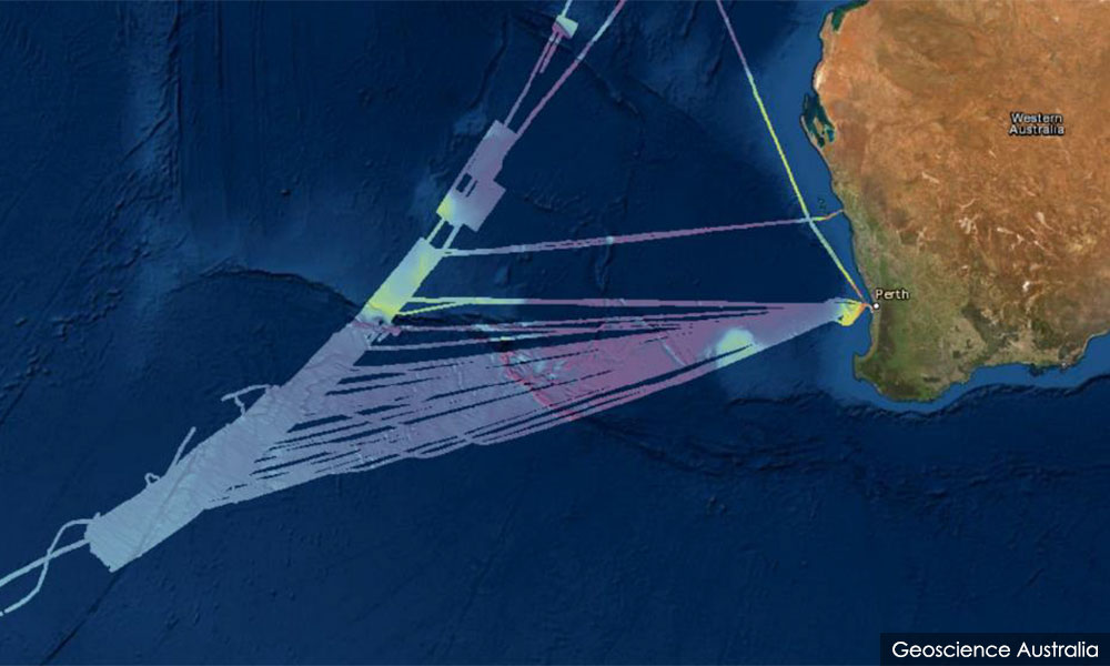

Aussie review finds no trace of MH370 but significant gaps remain
A fresh review of sonar data collected during the search for the missing flight MH370 has failed to turn up any trace of the aircraft, but significant gaps in the data meant a new lead on its whereabouts has yet to run cold.
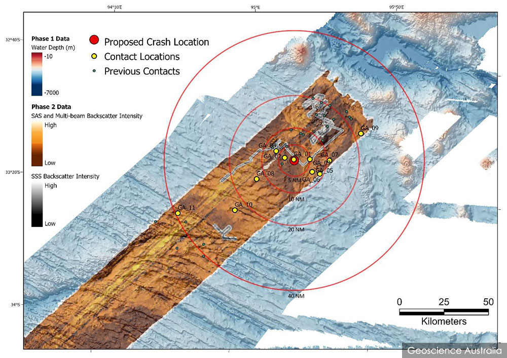
In a joint statement yesterday, the Australian Transport Safety Bureau (ATSB) and Geoscience Australia said the review identified 11 new “contacts” that were not analysed during the original search.
Eight of the objects were assessed to be likely to be...
A fresh review of sonar data collected during the search for the missing flight MH370 has failed to turn up any trace of the aircraft, but significant gaps in the data meant a new lead on its whereabouts has yet to run cold.
In a joint statement yesterday, the Australian Transport Safety Bureau (ATSB) and Geoscience Australia said the review identified 11 new “contacts” that were not analysed during the original search.
Eight of the objects were assessed to be likely to be geological features while the other three were likely to be of human origin, but none of them was consistent with an aircraft debris field.
“This data allowed us to detect objects as small as 30cm by 30cm. If the aircraft was within the area we have reviewed, the sonar data would have shown a scatter field of highly reflective debris,” said Geoscience Australia CEO James Johnson.
“The Geoscience Australia report notes that it is highly unlikely that there is an aircraft debris field within the area reviewed,” ATSB chief commissioner Angus Mitchell added.
The review entailed spending two months sifting through high-resolution sonar data for approximately 4,900km2 of seabed in the Indian Ocean, amounting to some 81,000 files totalling 3 terabytes.
However, the report also noted significant gaps in the data reviewed.
Only 29pct of area covered
The Geoscience Australia report is dated March 8 but was only made public yesterday.
It acknowledges that the area covered by the review is only 29 percent of the 17,000km2 area that the ATSB requested.
“The remaining area (71 percent) contained either Ocean Infinity search data, shipborne low-resolution (>30m) multibeam sonar data acquired during Phase 1, or no data,” the report said.
The low-resolution data was omitted because it lacked the resolution needed to identify aircraft debris.
Data collected by the Malaysia-contracted vessel Ocean Infinity in January 2018 was not analysed because Geoscience Australia didn’t have access to that data.
In addition, there were 72.72km2 of “data holidays” where the data was non-existent or of low quality for various reasons such as equipment failure and terrain avoidance.
Most of the data holidays were already identified in previous analyses, but another 1.57km2 of missing data was identified in the new review.
“Review of the Ocean Infinity search data and additional data acquisition would be required in order to definitively ascertain if the aircraft rests in these areas,” the report said.
Credible expert
The aviation news site Airline Ratings quoted British aerospace engineer Richard Godfrey saying “the previous search has in principle skipped a significant portion of the search area with the ‘holidays’ and the use of equipment with insufficient performance (resolution) to find the target.
“MH370 could easily have ended up in one of these insufficiently searched areas.”

For comparison, the 17,000km2 area requested for review is larger than the size of Kelantan, whereas the 4,900km2 area actually reviewed is about half the size of Kedah. The 72.72km2 data holiday is nearly double the size of Putrajaya.
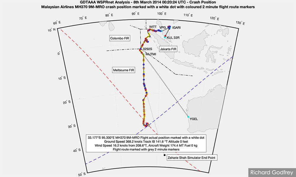
The ATSB had asked Geoscience Australia to revisit the search data for an area within 40 nautical miles of a potential crash site that Godfrey had identified after he published a series of papers analysing anomalies in the WSPRnet amateur radio network that could have been caused by interference from MH370.
He had used the anomalies and other data to deduce MH370’s likely flight path and crash site.
The ATSB previously acknowledged that Godfrey is a credible expert on MH370’s disappearance, but said the bureau lacked the necessary expertise to assess his papers and the validity of his claims.
After the review was announced in February, Malaysia’s Transport Ministry had said it would consult the ATSB regarding the review.
“Any further discussions with the governments of China and Australia will be held based on credible evidence which can lead to results in any new search for the missing aircraft,” it said at the time.
239 people on board
MH370 took off with 239 people on board from Kuala Lumpur International Airport to Beijing on March 8, 2014, but mysteriously turned towards the Indian Ocean instead after its tracking equipment was turned off.
It is presumed to have crashed somewhere thousands of kilometres west of Perth, along a wide swath that became known as the “Seventh Arc” based on satellite metadata.
Fragments of the aircraft have washed ashore in various places, but three years of underwater search efforts for the main wreckage came back empty-handed. It was reported that the search had cost around A$200 million (RM680 million) that was mostly borne by the Malaysian government.
Godfrey’s proposed crash site lies within this arc and a significant portion of the surrounding area was already searched during that period.
The review is a revisiting of the data collected during the search to “re-validate that no items of interest were detected in the data captured during the original search in that area”.
An investigation determined that the aircraft controls were likely deliberately manipulated, but no firm conclusion can be reached unless the wreckage is found.





Are you sure you want to delete this comment?
This action cannot be undone.